Monday, November 29, 2010
Sunny Sunday
Some beautiful photos of Paradise Meadows in the snow, during the latest snowshoe excursion by the Comox District Mountaineering Club to Croteau Lake. Another group went back-country skiing in the same area.
Sunday, November 21, 2010
Start of Winter in the Meadows
Winter excursions in Paradise Meadows have begun in earnest - here is a link to a report & photos from the Comox District Mountaineering Club .
Wednesday, November 17, 2010
Avalanche Reports
Current avalanche conditions will be posted regularly all winter on the Vancouver Island Avalanche Bulletin website. The reports are posted by Island Alpine Guides who also offer avalanche training courses at Mt. Washington. The indoor classroom sessions are held at the Strathcona Park Wilderness Centre, which is available for rent for meetings & community groups - check the website for more info including a floor plan of the downstairs meeting room.
Monday, November 15, 2010
Snow on the Plateau
Lots of snow already on the Plateau - here are some photos from a recent excursion by a Club Tread member.
Sunday, November 14, 2010
Story of the Forbidden Plateau
One of the most common questions at the Wilderness Centre was about the origin of the name 'Forbidden Plateau'. There is a colourful story to the source of the name!
Ruth Masters summarizes it all in her introduction to "History of Forbidden Plateau 1920-86" at the Courtenay & District Museum :
"Nowhere in my searches did I find any authentic Indian history or legends dealing with the Plateau. The "Forbidden" idea appears to have originated from the Comox Argus editor, Ben Hughes' reading the diary of Dr. Robert Brown, early explorer of Vancouver Island, who in 1864 recorded that the Comox Indians declined to accompany his party into the Puntledge River country "fear of the vengeance of the Scshahts (sic) and Opechasahts (sic) being too great and the attractions of the salmon fishery now commencing too strong for them." From this small beginning, all the yarns about evil spirits, hairy monsters, Indian women and children being murdered up there, the red snow representing their blood and so on, appear to have originated. I believe the 'Indian Legends' referred to in the numerous accounts about the naming of Forbidden Plateau all stem from the fertile imaginations of early Plateau promoters and explorers, namely the late Clinton S. Wood, who saw the potential for recreation on the Plateau, and journalist, and editor, Ben Hughes."
In 1967, Clinton S. Wood recorded his recollection in his summary about the Forbidden Plateau, as transcribed in the book. Wood was Waterworks Engineer for the City of Courtenay in 1925 at the time of his explorations into the Plateau area, to find a larger water source for the expanding City.
" So entranced was I with the great beauty of this sub-Alpine country that I made up my mind that the general public should be made aware of its great potential as a drawing card for the district and as a great recreational district for all, especially if it could be made a bit more accessible. I was Secretary of the Board of Trade, and had the idea that a bit of mystery added to the obvious attractions would help to publicise it. I wrote a small article to the Comox Argus and the idea was seized upon by Ben Hughes, the Editor, who wrote an article to the Vancouver Daily Province, using the word 'Plateau'. To this was added the word 'Forbidden' by Cecil Scott, and thus originated the name - "Forbidden Plateau"."
Trevor Davies, a founding member of the Comox District Mountaineering Club, recorded a similar reminiscence in 1983, also transcribed in the book:
"Ben Hughes was the first publisher of the Comox Argus (local newspaper), a wonderful man at making up stories. So he invented the story of the Indian war, when the Indians took all their wives up there, and there were some big hairy creatures of some kind, and the women disappeared, and the Indians have refused to go there ever since. That is how the name "Forbidden Plateau" and and the legends started; but there is absolutely no truth in these stories as far as the local Indians are concerned, but they became legends, and Ben printed articles in the Comox Argus, and away they went, - and they are now history. Obviously the Indians didn't go in there, because all their food was on the beach, and they weren't stupid like we are, they didn't go mountain climbing for no reason..."

All in all, a demonstration of the power of a story!
Ruth Masters summarizes it all in her introduction to "History of Forbidden Plateau 1920-86" at the Courtenay & District Museum :
"Nowhere in my searches did I find any authentic Indian history or legends dealing with the Plateau. The "Forbidden" idea appears to have originated from the Comox Argus editor, Ben Hughes' reading the diary of Dr. Robert Brown, early explorer of Vancouver Island, who in 1864 recorded that the Comox Indians declined to accompany his party into the Puntledge River country "fear of the vengeance of the Scshahts (sic) and Opechasahts (sic) being too great and the attractions of the salmon fishery now commencing too strong for them." From this small beginning, all the yarns about evil spirits, hairy monsters, Indian women and children being murdered up there, the red snow representing their blood and so on, appear to have originated. I believe the 'Indian Legends' referred to in the numerous accounts about the naming of Forbidden Plateau all stem from the fertile imaginations of early Plateau promoters and explorers, namely the late Clinton S. Wood, who saw the potential for recreation on the Plateau, and journalist, and editor, Ben Hughes."
In 1967, Clinton S. Wood recorded his recollection in his summary about the Forbidden Plateau, as transcribed in the book. Wood was Waterworks Engineer for the City of Courtenay in 1925 at the time of his explorations into the Plateau area, to find a larger water source for the expanding City.
" So entranced was I with the great beauty of this sub-Alpine country that I made up my mind that the general public should be made aware of its great potential as a drawing card for the district and as a great recreational district for all, especially if it could be made a bit more accessible. I was Secretary of the Board of Trade, and had the idea that a bit of mystery added to the obvious attractions would help to publicise it. I wrote a small article to the Comox Argus and the idea was seized upon by Ben Hughes, the Editor, who wrote an article to the Vancouver Daily Province, using the word 'Plateau'. To this was added the word 'Forbidden' by Cecil Scott, and thus originated the name - "Forbidden Plateau"."
Trevor Davies, a founding member of the Comox District Mountaineering Club, recorded a similar reminiscence in 1983, also transcribed in the book:
"Ben Hughes was the first publisher of the Comox Argus (local newspaper), a wonderful man at making up stories. So he invented the story of the Indian war, when the Indians took all their wives up there, and there were some big hairy creatures of some kind, and the women disappeared, and the Indians have refused to go there ever since. That is how the name "Forbidden Plateau" and and the legends started; but there is absolutely no truth in these stories as far as the local Indians are concerned, but they became legends, and Ben printed articles in the Comox Argus, and away they went, - and they are now history. Obviously the Indians didn't go in there, because all their food was on the beach, and they weren't stupid like we are, they didn't go mountain climbing for no reason..."

From 'Vancouver Island. Exploration. 1864' by Robert Brown, relating to his voyage up the Puntledge River, through to Port Alberni by way of Comox Lake
All in all, a demonstration of the power of a story!
Wednesday, November 10, 2010
Almost Snowshoe Time
Photographers & hikers from the Comox District Mountaineering Club were enjoying the most recent sunny day up at Paradise Meadows. Here is a link to their report.
Monday, November 8, 2010
Pink Sunrise

Sunday, November 7, 2010
Castlecrag Quake

On June 23, 1946 a 7.3 magnitude quake centred in the Forbidden Plateau area on Vancouver Island shook houses off their foundations and toppled brick walls & chimneys in the Comox Valley & beyond. Luckily it was a Sunday otherwise many buildings would have been occupied & injuries would have occurred.
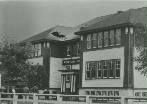
Hole in roof of Courtenay Elementary School where chimney fell
In Strathcona Park a well-known result of the earthquake is the rock slide off Mt. Colonel Foster which created Landslide Lake. Less well known perhaps is the change that occurred to Castlecrag Mountain.

Castlecrag 1943


Castlecrag 2010
Compare this 1943 photo of Castlecrag by Lynn Hilton with a current photo. Although the vantage point is slightly different, the change in the turret on the right can be seen - it now resembles more of a spire.
Wednesday, November 3, 2010
Sun & Snow

Tuesday, November 2, 2010
Mount Elma
Even when Mt. Albert Edward is not visible from the Paradise Meadows trailhead, two smaller mountains in the forefront, on the south shore of Lake Helen Mackenzie usually are: Mt. Brooks to the west and Mt. Elma to the east.

Theed Pearse himself has a lake named after him in the Plateau area of Strathcona Park. The name of Pearse Lake was adopted in 1939 after being submitted by Ruth Masters in 1935. It is interesting to note that in those days many local politicians & businessmen were avid hikers and expert naturalists.
Theed Pearse was also the first known owner of the land bordering Elma Bay (named after his wife) at the mouth of Black Creek, which eventually became Miracle Beach Provincial Park in 1950.

Mt. Elma from the south
Mt. Elma was named in 1939 for the wife of Theed Pearse, who over the course of his long life was a lawyer, Courtenay alderman & then mayor, and a knowledgeable naturalist. In 1968 at the age of 96 he self-published 'Birds of the Early Explorers in the Northern Pacific'. The text was transcribed by Norma Morton, a founding member of the Comox-Strathcona Natural History Society formed in 1966. (The name was changed to the Comox Valley Naturalists Society in 1997). Norma is still very active with the Society & is a wealth of historical information.Theed Pearse himself has a lake named after him in the Plateau area of Strathcona Park. The name of Pearse Lake was adopted in 1939 after being submitted by Ruth Masters in 1935. It is interesting to note that in those days many local politicians & businessmen were avid hikers and expert naturalists.
Theed Pearse was also the first known owner of the land bordering Elma Bay (named after his wife) at the mouth of Black Creek, which eventually became Miracle Beach Provincial Park in 1950.
Subscribe to:
Posts (Atom)